Nielson Nigeria Limited has experience and expertise to provide technologies and services related to the managing of 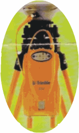 geographically reference information, specifically in, Mapping, Surveying and Geographical Information System.(GIS)
The company supplies services in the fields of acquisition processing interpretation, storage/retrieval and maintenance of geographical data. The service range from conventional Land, Swamp, Geophysical and Hydrographic Surveying to Digital mapping projects, Computer Aided Drafting, GIS and photogrammtry technologies.
We conduct surveys on Land, Swamps and offshore using latest technologies. Various levels of expertise are available in Geodesy, Hydrographic surveying, underwater Engineering. Geophysics and Computer services.
Dredging companies, utilities companies, Government agencies, planners Engineering contractors and individuals involved in making decision regarding the use of land and environmental resources, depending on complete and accurate survey data.
OIL & GAS PIPELINE & LOCATION DEVELOPMENT SERVICES
Nielson Nigeria LTD undergoes various oil & Gas field development survey services, which include but not limited to: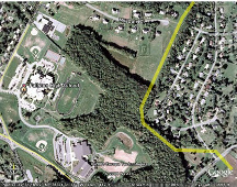
- Preliminary investigation survey to present complete picture of field situation to give advice and enhance decision making.
- Full preparation (FP) surveys.
- Pipeline route surveys (R.O.W)
- Pipeline/location and Engineering facilities AS-BUILT survey to provide comprehensive summary for future maintenance and management
OFFSHORE AND INLAND WATERWAYS SURVEYS
 We provide services on Hydrographic, marine and bathymetric surveys for dredging, sand search site under water engineering and Rig position with the use of latest hydrographic equipment which is very accurate and reliable.
TOPOGRAPHICAL CADASTRAL AND UTILITIES SURVEY
Nielson services in respect of utilities management involves:
- Survey services in various aspects of system definition design and inception
- Customization of GIS as dedicated facility management system
- Utility data facts gathering and data validation.
CADASTRAL
Our service in property survey and registration include:
- Individual property survey, charting and Deposition with the statutory authority.
- Layout survey and planning
- Customization of GIS as cadastral information system for integrity control and assurance for certificate of occupancy administration.
- Provision of street guide maps for cities and major town for Township administration
This project involved site plan preparation, zoning, civil design engineering, utility plans, road improvement plans, Department of Transportation Right-of-Way | Sample Topographic Map. |
 Improvements, Hydrology, water system design, construction survey staking, Engineer's Certified As-Built Plans.